The Oil and Gas Addendum
Can a Hurricane or Flooding Change Who Owns the Oil and Gas Under a River Bank?
Can a Hurricane or Flooding Change Who Owns the Oil and Gas Under a River Bank?
By: Robert J. Burnett, Esquire
Floods are among the most common and costly natural disasters in the United States. To protect property from this risk, landowners who own land along rivers, lakes and coastal bays often purchase a separate “flood insurance” policy to cover damage caused by overflowing rivers, heavy rains or coastal storm surges. The coverage is designed to pay for damage caused by flooding to the insured structure and, if selected, its contents. Do landowners need similar insurance to protect against the loss of their oil and gas rights? Such policies are generally not offered but maybe they should be. Overflowing rivers, heavy rains and coastal storm surges can, and do, affect and change the ownership of riparian[1] oil and gas rights.
For example, let’s assume your family owns an 85 acre farm along a sharp bend in the Allegheny River in Armstrong County. Your family has owned the farm since the 1880’s. In 2010, your family entered into an oil and gas lease with ABC Oil Co. (“ABC”). Shortly thereafter, ABC drilled and fraced a horizontal wellbore (i.e. know as the “Tomlin #1H Well”) that passes directly underneath your farm and about 800 feet from the eastern bank of the Allegheny River. However, as a result of the heavy rains and flooding caused by remants of Hurricane Ivan in 2004 and Tropical Storm Ida in 2021, the course of the Allegheny River has changed and expanded over the years. The eastern bank of the river is now 1,000 feet further east, effectively submerging nearly half of family farm:
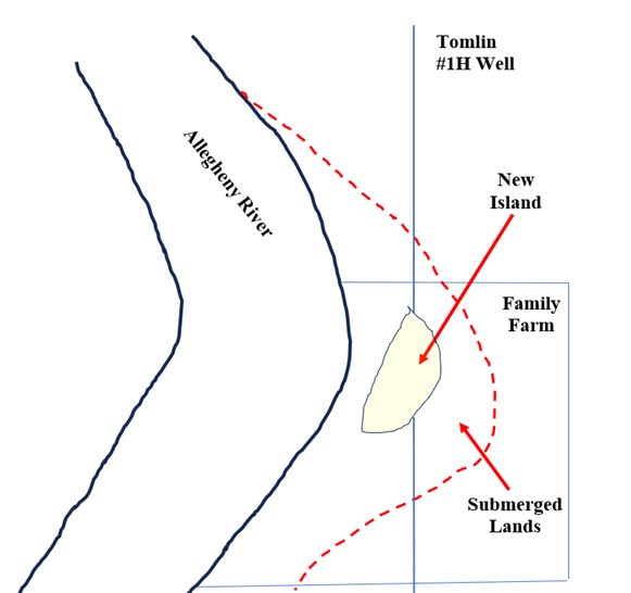
As depicted in the above drawing, portions of the Tomlin #1H well are now entirely under the Allegheny River and the “new” island that was “formed” in the middle of the family farm.
In 2024, you receive a letter from ABC stating that all royalties attributed to the 2010 Lease will be placed in “suspense” because of a competing ownership claim. You are frustrated, angry and confused. Who could possibly be asserting a competing ownership claim? ABC informs you that because the Allegheny River is a “navigable” waterway, the Commonwealth of Pennsylvania is asserting ownership of the oil and gas formations that are now under the expanded channel of the river as well as the new “island”. The Commonwealth contends that as a result of hydraulic “accretion” over the last 25 years, the channel of the Allegheny River moved eastward and, as the owner of the entire riverbed, the Commonwealth now owns all of the oil and gas underlying the newly formed island and the surrounding submerged lands. As such, the Commonwealth argues that it should receive royalties generated by the Tomlin #1H Well. Is this legally possible? To the surprise and dismay of many landowners, the answer is “maybe”. The recent decision by the North Dakota Supreme Court in State of North Dakota v, Leland, et al., 2026 ND 99 (May 7, 2026) explored this troubling and complex question.
Before we discuss the substance of the Leland decision, a brief review of riparian oil and gas rights is warranted. As I have written before, the ownership of oil and gas under roads and railroads can be complex and confusing. See, The Neale Rule: Who Really Owns the Oil and Gas Under Railroads? (May 20, 2024): The Strip and Gore Doctrine – Who Really Owns the Oil and Gas Under Roads and Highways? (July 12, 2023); The Centerline Presumption – Who Really Owns the Oil and Gas Under Roads and Highways (Part II)? (February 29, 2024). Questions regarding the ownership of oil and gas under rivers, streams and lakes can be equally challenging and confusing.
The starting point when analyzing riparian oil and gas ownership is whether the adjacent waterway is “navigable” or “non-navigable.” It is well-settled that title to land underlying navigable waterways is owned by the Commonwealth. See, Mountain Properties v. Tyler Hill, 767 A.2d 1096 (Pa. Super. 2001); see also, Delaware Ave LLC v. DCNR, 997 A.2d 1231 (Pa. Commw. 2010) (“[O]nce a body of water meets the navigability test, title to the bed is in the Commonwealth”). If the waterway is navigable, then the adjacent landowner’s ownership extends only to the low watermark. This means that the Commonwealth owns the riverbed and all oil and gas and other minerals underlying the bed. Conversely, the beds of non-navigable waterways are “owned by the property owners of the land along the waterways.” See, Lehigh Falls Fishing Club v. Andrejewski, 735 A.2d 718 (Pa. Super 1999). In such cases, the adjoining landowner’s ownership extends to the middle of the stream or, if he owns the land on both sides, then he owns the entire streambed. The navigability of a particular waterway can be established by falling into one of three distinct categories: i) being classified as a Great River, ii) navigability-at-law or iii) navigability-in- fact. We briefly examine each category below.
In 1826, the Pennsylvania Supreme Court in Shrunk v. Schuylkill Navigation Company, 14 Serg & Rawle 71 (Pa. 1826) recognized nine principal or “great” rivers which the Court designated navigable as a matter of law. This characterization remains valid today. The nine principal rivers are the Ohio, the Monongahela, the Youghiogheny, the Allegheny, the Susquehanna, the Juniata, the Schuykill, the Lehigh and the Delaware. Pennsylvania, unlike other jurisdictions, holds that a “navigable” waterway is considered navigable throughout its entire length regardless of intervening hydraulic conditions. See, Lehigh Falls Fishing Club, 735 A.2d at 722 (“once a river is held to be navigable, its entire length is encompassed…”). This broad rule means that even the shallow headwaters of one of the Great Rivers, as well as other segments of the rivers with obstructions or rapids, could be nonetheless deemed “navigable” in the legal sense.
The second category are those waterways that were specifically designated as a “public highway” by legislative act. In the late 1790’s and early 1800’s, the General Assembly often declared certain streams and rivers as public highways. Although these designations were made many years ago, if a waterway was deemed navigable by one of these acts, that designation remains valid today. See, Leaf v. Pennsylvania Company, 112 A. 243 (Pa. 1920) (“…but in this state the rule of title to low water make applies to rivers actually navigable or made so by legislature…”). In other words, a stream or creek that has not supported commercial traffic since the 1830’s may still be characterized as a navigable waterway today if there is an official “Act of Assembly” previously designating that waterway as a highway.
The third category are those waterways that are “navigable” by virtue of their historical use. To qualify under this category, the waterway must actually have been used as a “highway for commerce.” See, Lakeside Park Co. v. Forsmark, 153 A.2d 486 (Pa. 1959). The Lakeside court noted that the size of the waterway or its capacity to float a boat is not dispositive:
“[R]ather it should depend upon whether the water is used or usable as a broad highway for commerce and the transport in quantity of goods and people…”
Any historical commercial use, however brief, can satisfy this criteria. Many shallow streams and creeks in Pennsylvania fall within this category since they often supported “one-way” commercial traffic – the shallow draft wooden barges were floated down the waterway and then dismantled and sold as lumber at the mouth of the river. This “one-way” river traffic was quite common prior to the construction of the Pennsylvania railroad in 1850. Such streams and rivers, despite their shallow depth, were often the only viable transportation option in the early to mid-1800’s. As such, when evaluating whether a particular waterway may be “navigable-in-fact” one must examine and research local newspaper accounts, census records and other contemporaneous historical records from the 1800’s to ascertain how that particular waterway may have been used throughout its history.
So, the general rule is this: if a river or lake is navigable, then the Commonwealth owns the oil and gas under the waterway. But, a determination that a certain waterway is navigable may not always end the analysis. Riverbanks and shorelines often change due to flooding, erosion and reliction. Determining who owns the oil and gas under an eroded bank, a new in-channel island or a flooded channel is governed by two unique doctrines of oil and gas law known as “accretion” and “avulsion”.
Accretion is implicated if there is a gradual addition or erosion of soil to riparian lands. The action of waves or current, over time, can cause soil, dirt or gravel to accumulate on or erode from the shore or bank. See, Stop the Beach Renourishment Inc. v. Florida Dept. of Env’t Protection, 560 U.S. 702, 708 (2010) (“[A]ccretions are additions of alluvion (sand, sediment or other deposits) to waterfront land. . . In order for an addition to dry land to qualify as an accretion, it must have occurred gradually and imperceptibly. . .”). On the other hand, when land is separated or submerged suddenly, the doctrine of avulsion is triggered. See, JP Furlong Enterprises v. Sun Exploration, 423 N.W.2d 130 (N.D. 1988) (“avulsion refers to the sudden inundation or sweeping away of land resulting from a sudden change in the course of a waterbody”). The distinction is critical. When a river channel is altered or changed via accretion, the state, and not the riparian landowner, gains exclusive title to the riverbed under the expanded or eroded bank. See, Arkansas v. Tennessee, 246 U.S. 158 (1918) (“[W]hen the bed and channel of a river are changed by the natural and gradual processes. . . the boundary follows the varying course of the stream. . .”). The same principle applies to the creation of new islands that may form in an existing river channel. See, Hogue v. Bourgios, 71 N.W. 2d 47 (N.D. 1955) (“[W]here an island arises in a navigable river apart from riparian owners’ land. . .such owners cannot claim title thereto by reason of their riparian rights. . .”). Conversely, an avulsive event does not alter or change property boundaries or ownership: the submerged land or expanded riverbank remains the property of the riparian owner. See, Moon Township v. Findley Township, 553 A.2d 500 (Pa. Commw. 1989) (“. . .if the stream from any cause. . . suddenly leaves its old bed and forms a new one. . . the resulting change of channel works no change of boundary. . .”); Philadelphia Company v. Stimson, 223 U.S. 605 (1912) (“. . . where a stream suddenly and perceptibility abandons its old channel, the title is not affected, and the boundary remains at the former line”). In sum, how and why the riverbank changed or expanded is often dispositive as to ownership of the underlying oil and gas.
Back to Leland. At issue was ownership of the oil and gas underlying two (2) distinct geographic features that formed within the Yellowstone River channel in McKenzie County, North Dakota. The two areas were known as the “West Bank” and the “North Island”. The State of North Dakota argued that because the Yellowstone River was a navigable waterway and that because both the West Bank and the North Island gradually formed over a period of years between 1939 and 1949, the doctrine of accretion granted the State title to the oil and gas underlying the new riverbank and the new island. Conversely, the riparian landowners asserted that the creation of the North Island was the result of sudden and violent avulsive event that flooded their land. As such, under North Dakota law, the property boundaries did not, and could not, change and ownership of the oil and gas underlying the North Island should remain with the riparian owners. The riparian owners, who only owned property along the eastern bank of the Yellowstone River, further argued that they owned the oil and gas under the West Bank because their 1950 deeds stated that their western property boundary was actually the Montana – North Dakota state boundary.[2] In essence, the riparian owners contended that as their eastern property boundary eroded into the Yellowstone River, it nonetheless re-appeared on the other side of the river as the new West Bank was formed. The oil and gas driller, Whiting Oil and Gas Corporation, commenced a quiet title and interpleader action in 2015 seeking a judicial declaration as to who owned the oil and gas under the West Bank and the North Island.
After a four day bench trial, the trial court ruled that i) the West Bank was originally formed as an in-channel island via accretion, ii) that the riparian landowners nonetheless owned the oil and gas under the West Bank by virtue of their 1950 deeds from the State and iii) the North Island was formed by an avulsive event and therefore the oil and gas underlying the island was owned by the riparian landowners.[3] The parties appealed to the North Dakota Supreme Court.
The North Dakota Supreme Court issued a mixed ruling. With respect to the North Island, the panel affirmed opining that the photographic evidence supported the conclusion that an avulsive event occurred sometime between 1939 and 1949. The High Court rejected the State’s theory that North Island was formed as the result of the gradual deposit of soil and gravel in the existing river channel and observed that when a stream suddenly “divides itself and surrounds land belonging to the owner of the shore, and therefore forms an island, the island belongs to the shore owner.” As such, the oil and gas under the North Island belonged to the riparian owners.
The Leland court reached a different conclusion as to the West Bank. The panel affirmed the district court’s finding that the West Bank initially formed as an island in the river channel before later attaching to the western river bank. Because the West Bank originated as an in-channel island, any enlargement or expansion of that land mass belonged to the State (“[T]he owner of an island is entitled to land added thereto by accretion to the same extent as the owner of land on the shore of the mainland”). The fact that the island later “attached” to the western river bank over the years did not negate or diminish the State’s title to the original in-channel land. But the panel rejected the riparian owners’ contention that their 1950 deeds extended their lots across the Yellowstone River and hence included the newly formed West Bank:
“[T[he district court erred as a matter of law when it decided that the lots extended across the Yellowstone River. Based on the court’s factual findings as to how the West Bank formed. . . the West Bank was never part of the lots the State conveyed (in 1950].”
Accordingly, the North Dakota Supreme Court reversed the district court’s finding that the riparian owners had title to the oil and gas underlying the West Bank.
As illuminated by the Leland decision, determining ownership of the oil and gas under rivers, streams and coastlines can be complex and fact-intensive. If you own oil and gas rights that abut a waterway and have questions regarding the nature, scope and extent of your holdings, please contact Robert J. Burnett, Esquire at 412-288-2221 or rburnett@hh-law.com.
[1] The term “riparian” refers to that body of legal privileges and rights held by a landowner whose property touches or abuts a river, lake or other natural watercourse.
[2] The official boundary between Montana and North Dakota lies just beyond the western bank of the Yellowstone River.
[3] The district court also determined, as a threshold matter, that the Yellowstone River was a navigable waterway.
About Us
Oil and gas development can present unique and complex issues that can be intimidating and challenging. At Houston Harbaugh, P.C., our oil and gas practice is dedicated to protecting the interests of landowners and royalty owners. From new lease negotiations to title disputes to royalty litigation, we can help. Whether you have two acres in Washington County or 5,000 acres in Lycoming County, our dedication and commitment remains the same.
We Represent Landowners in All Aspects of Oil and Gas Law
The oil and gas attorneys at Houston Harbaugh have broad experience in a wide array of oil and gas matters, and they have made it their mission to protect and preserve the landowner’s interests in matters that include:
- New lease negotiations
- Pipeline right-of-way negotiations
- Surface access agreements
- Royalty audits
- Tax and estate planning
- Lease expiration claims
- Curative title litigation
- Water contamination claims

Robert Burnett - Practice Chair
Robert’s practice is exclusively devoted to the representation of landowners and royalty owners in oil and gas matters. Robert is the Chair of the Houston Harbaugh’s Oil & Gas Practice Group and represents landowners and royalty owners in a wide array of oil and gas matters throughout the Commonwealth of Pennsylvania. Robert assists landowners and royalty owners in the negotiation of new oil and gas leases as well as modifications to existing leases. Robert also negotiates surface use agreements and pipeline right-of-way agreements on behalf of landowners. Robert also advises and counsels clients on complex lease development and expiration issues, including the impact and effect of delay rental and shut-in clauses, as well as the implied covenants to develop and market oil and gas. Robert also represents landowners and royalty owners in disputes arising out of the calculation of production royalties and the deduction of post-production costs. Robert also assists landowners with oil and gas title issues and develops strategies to resolve and cure such title deficiencies. Robert also advises clients on the interplay between oil and gas leases and solar leases and assists clients throughout Pennsylvania in negotiating solar leases.

Brendan A. O'Donnell
Brendan O’Donnell is a highly qualified and experienced attorney in the Oil and Gas Law practice. He also practices in our Environmental and Energy Practice. Brendan represents landowners and royalty owners in a wide variety of matters, including litigation and trial work, and in the preparation and negotiation of:
- Leases
- Pipeline right of way agreements
- Surface use agreements
- Oil, gas and mineral conveyances
